Monday, September 23, 2024

Tag Archives: Displacement Alert Project

ANHD Releases New District-Level Tenant Displacement Risk Tracking Tool

ANHD Releases New District-Level Tenant Displacement Risk Tracking Tool

The Association for Neighborhood & Housing Development (ANHD) is excited to release the next phase of our Displacement Alert Project (DAP): DAP District Reports. DAP Reports provide monthly updates on harassment and displacement risk in rent stabilized buildings across New York City’s 59 community districts. The reports are a crucial new tool for grassroots groups, tenant organizers, community members, and elected officials. They allow you to:

  • Access lists of at-risk buildings arranged by address, color-coded, and sorted by each community district.
  • View reports on your computer, phone, or print them out in a clear format to take offline and into the field.
  • Look back at reports from previous months.
  • Navigate directly to a property page on ACRIS, HPD, DOB, DOF tax bills, OASIS map, and Google Maps.

Tenant organizers can use the reports to identify the most at-risk buildings in their neighborhoods and prioritize outreach. District Reports data can support work to keep tenants in place and preserve rent stabilized units by making organizers’ research faster and easier.

Community members can use the reports to understand threats to tenants and existing affordable housing at the neighborhood level.

Elected officials can use the reports to monitor the risk to stabilized buildings in their districts and their offices can use them to support tenants facing harassment.

And, while DAP Map provides a citywide view of displacement risk, DAP District Reports give researchers and the public the opportunity to understand current risk in detail and at the neighborhood level.

Here is a small sampling of what we found this month with the DAP District Reports:

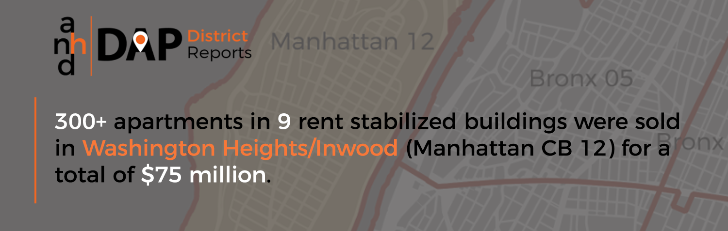
  • 300+ apartments in 9 rent stabilized buildings were sold in Washington Heights/Inwood (Manhattan CB 12) for a total of $75 million.

High sales prices can mean the new owner plans to displace existing stabilized tenants to make large profits.

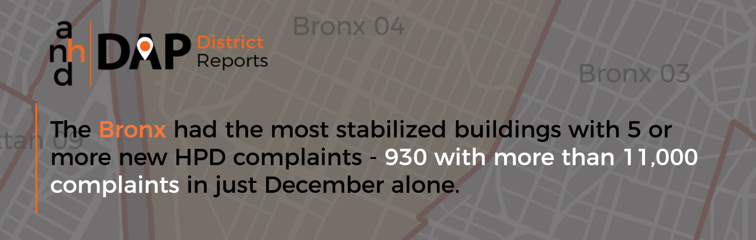
  • The Bronx had the most stabilized buildings with 5 or more new Housing Preservation & Development (HPD) complaints – 930 with more than 11,000 complaints in just December alone.
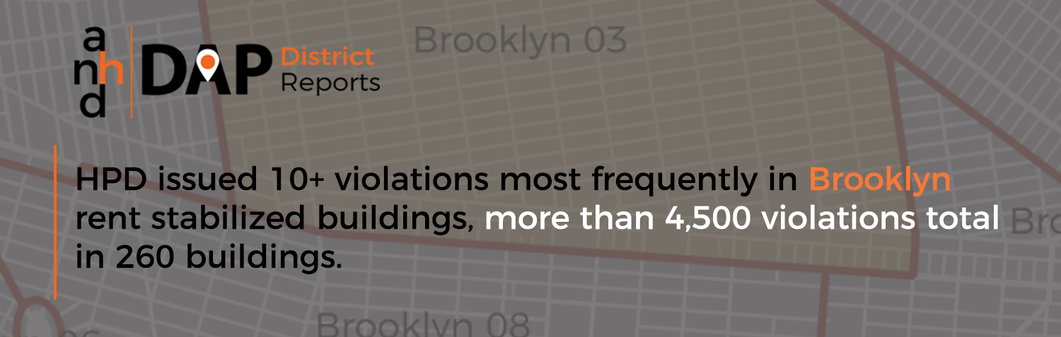
  • HPD issued 10+ violations most frequently in Brooklyn rent stabilized buildings, more than 4,500 violations total in 260 buildings.

Buildings accumulating many HPD complaints or violations in a month can indicate a landlord is actively harassing or neglecting tenants in an effort to push them out of their apartments.

DAP Reports build off ANHD’s interactive data visualization DAP Map, which was launched last year, taking public data related to housing and presenting it in a more easily accessible way for users to understand where there are heightened risks of displacement in New York City. It compiles fragmented information from various public records and databases, and makes it more easily accessible for advocates – especially organizers and activists – by displaying it in one place, with intuitive, color-coded metrics.

For more information on how to use the DAP District Reports, visit the Tutorial Page. For specific questions or press inquiries, please contact Lucy Block at lucy.b@anhd.org.

ANHD Releases Interactive On-Line Data Map That Pinpoints Displacement

Displacement Alert Project Map Gives Activists and Policy Makers Key Information to Proactively Address the Displacement Crisis

The tenant displacement crisis is at the center of neighborhood concerns and City policy focus. We cannot allow market forces to price and push out our City’s diverse communities. ANHD today released the Displacement Alert Project Map (the DAP Map) that, for the first time, presents key information in an interactive, easy-to-use map that local activists, service providers and policy makers have long needed.

www.dapmapnyc.org

The DAP Map is a web-based, building-by-building map designed to show where residential tenants may be facing significant displacement pressures across New York City. Read the exclusive report about the DAP Map in this piece published today in the New York Times –  New Tool Shows New York Neighborhoods At Risk Of Rent Hikes

The DAP Map has three data view options and one combined risk score view. Each view option is based on unique data compiled by ANHD. The map shows previously unavailable building-level data, and color-codes buildings by risk-level so the information is clear and intuitive:

  • Is there a high rate of loss of rent-regulated tenants in the building?
  • Do NYC Department of Buildings permits indicate a high rate of tenant turnover?
  • Was the building sold for a price that might indicate a speculative investment strategy? 
  • Where do we see building facing multiple combined risks?

Clicking on any individual building and details about that particular risk in that building appears in a pop up box. The DAP Map can also be searched by entering an individual building address.

ANHD developed the DAP Map as a strategic tool for tenants, community groups, service providers and policy makers who want to address NYC’s displacement crisis. Our ANHD neighborhood groups know that growing market pressures are impacting existing affordable housing, and increasing tenant harassment and displacement in many neighborhoods. The DAP Map can be used to:

  • Identify at-risk buildings.
  • Provide proactive outreach and education tenants.
  • Identify where and why neighborhoods might be experiencing a wave of displacement pressure.
  • Align government policies on displacement to real-time displacement forces and trends. 

The DAP Map data is currently viewable only at an individual building level – aggregate data will be included in the next phase of the project. Meanwhile, ANHD analyzed the aggregate level data and found the following neighborhood patterns:

  • There are 96,000 multi-family buildings in the data set. They all had at least one indicator of potential displacement concern: sold in 2015, at least one rent regulated unit since 2007, or had a residential DOB since 2013.
  • New York City has lost over 156,000 rent-regulated units from 2007 to 2014.
  • Nearly 26% of the buildings on the DAP Map have a high risk score, suggesting increasing rents.
  • In over 5,400 buildings, the 2015 sales price per unit increased by more than double the 2010 area average.
  • Just 10 zip codes account for one-quarter of all the buildings in NYC that lost a high percentage of rent regulated units between 2007 and 2014.
  • Twenty-five zip codes account for one-half of all the NYC buildings that lost a high percentage of their rent regulated units in that same time period.
  • In those same 25 zip codes, there is a correspondingly high number of Department of Buildings permits, with 16 of these zip codes showing exceptionally high DOB permit activity.
  • In those same 25 zip codes, there is a correspondingly high number of exceptionally high per-unit property sale prices. In 12 of those zip codes, the average per-unit sale price was 150% above the average price in the surrounding area.

New York’s low-income communities, communities of color, and immigrant communities have been disproportionately impacted segregation, redlining, and predatory practices, and are increasingly feeling pushed out of our City. ANHD and our members are committed to stopping New York City’s growing displacement crisis and building a more equitable future for all of our City’s neighborhoods.

The DAP Map can be a tool to uncover problem buildings and patterns that City policy can help to address. This past spring, Mayor de Blasio committed to enacting a new, city-wide Certificate of No Harassment program as one key tool to help prevent displacement and preserve affordable housing.